

الوصف
Real Landscape Generation lets you create accurate terrain directly inside the Unreal Editor using real-world geographic data.
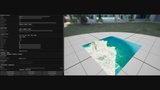
Enter latitude, longitude and area size, download elevation data from multiple providers, preview the terrain in 3D, and generate a fully configured UE5 Landscape with one click.
Elevation Providers:
- Mapzen Terrain Tiles
- SRTM 30m (NASA)
- ALOS 30m (JAXA/OpenTopography)
Satellite Imagery Providers:
- ESRI World Imagery (no API key required)
- Mapbox Satellite
- Bing Maps Aerial
Key Features:
- Interactive 3D terrain preview with heightmap color visualization
- Satellite imagery overlay on 3D preview
- Sea/Land split with configurable sea level threshold
- Heightmap export (PNG 16-bit / RAW 16-bit)
- Satellite imagery export as PNG
- One-click Landscape generation with correct real-world scale
- Automatic satellite material creation and application
- Full Landscape configuration (section size, components, scale, location)
- Tile caching for faster repeated downloads
- Custom material preview on terrain
- Wireframe/Solid toggle, Show/Hide land and sea independently
Requirements:
- ESRI satellite works without API key
- Mapbox and Bing require free API keys
- ALOS requires free OpenTopography API key
- This plugin requires the ProceduralMeshComponent plugin to be enabled
Need help or want to share feedback?
Support: [email protected]
Report a bug: https://www.pixelsdesign.it/bug-report.html
Request a feature: https://www.pixelsdesign.it/feature-request.html