



説明
GEOSCAPE - Craft Real Worlds
Give GeoScape a latitude and longitude. It fetches OpenStreetMap buildings and roads plus global elevation for your bounding box, georeferences everything automatically, and builds a to-scale level inside the editor: a real Landscape with slope-aware Nanite buildings and draped roads, batched for World Partition. No QGIS, no manual GeoJSON exports, no heightmap conversion pipeline.
ONE COORDINATE IN, A FINISHED LEVEL OUT
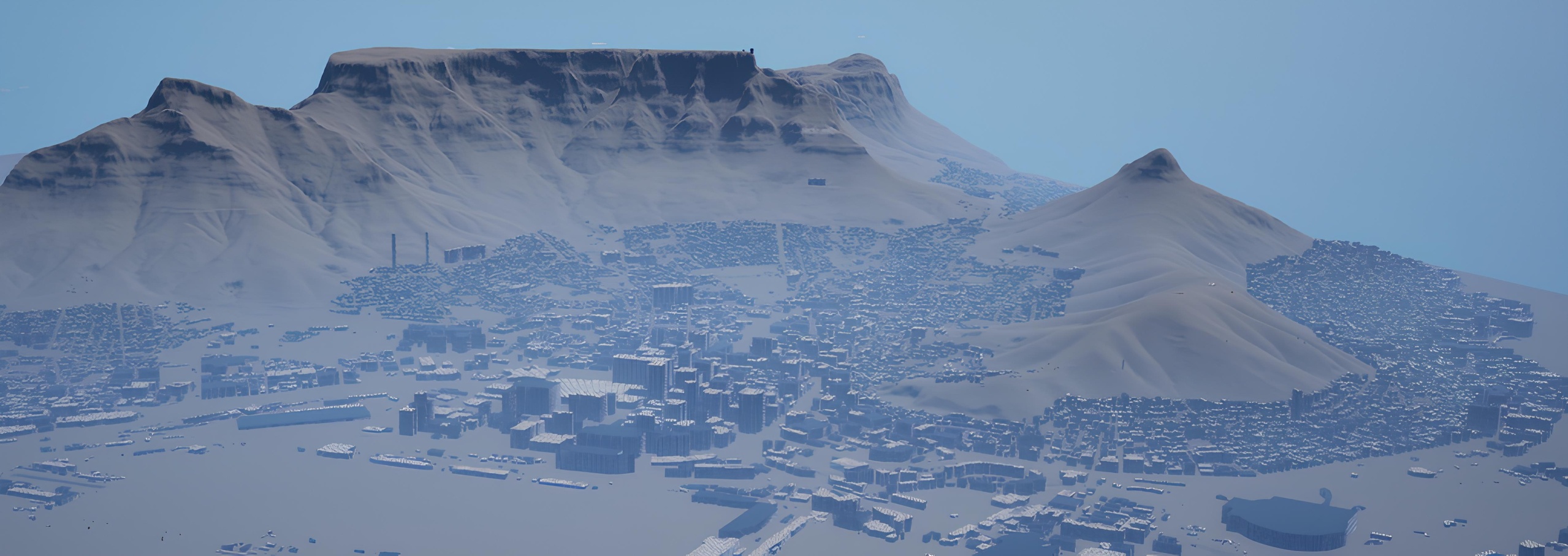
One lat/long and an area size is the whole input, from the GeoScape panel, Blueprint, or Python. Example: central Cape Town at 1 km2 produces a 168x168 Landscape with ~44 m of relief, 768 buildings at real heights, and 3,208 draped road segments, streamed and playable.
THREE LAYERS OF EDITABLE UNREAL GEOMETRY
- Terrain: a real ALandscape from global elevation tiles, sized to your bounding box with an auto-chosen Z scale
- Buildings: OpenStreetMap footprints extruded at real heights, slope-aware so nothing floats or buries on a hill, baked to Nanite
- Roads: centerlines become draped ribbons at per-class widths, lifted above the terrain and two-sided
Everything is editable Unreal geometry, not a baked mesh dump, and everything is batched into cells (one mesh and actor per cell) for World Partition streaming and HLODs.
LIVE FETCH, OR BRING YOUR OWN DATA
GeoScape ships pointed at public OpenStreetMap and elevation sources, but every source, projection, and field name is configurable:
- Parse your own GeoJSON FeatureCollection from any city open-data portal or export
- Map any provider's schema: tell GeoScape which properties carry height, storeys, width, or lanes
- Point the Overpass and elevation endpoints at your own mirror or a commercial provider for production and bulk use
- Drive the whole pipeline from a subsystem call in Blueprint or Python, for batching many locations or wiring into your own tools
NETWORK USE AND DATA LICENSING (PLEASE READ)
GeoScape makes outbound HTTPS requests at author time only, to fetch map data for your chosen area: the Overpass API (OpenStreetMap) and the AWS Terrain Tiles open dataset by default, both configurable. Packaged games make no network requests and contain no GeoScape runtime dependency on these services.
GeoScape does not redistribute map data; it is fetched at author time to your machine. A GeoScape license covers the software only. Map data carries its own licenses, most notably OpenStreetMap data under the ODbL, which has attribution and share-alike terms you must follow in anything you distribute. Elevation data is via the AWS Terrain Tiles open dataset.
Full documentation and install guide: https://geoscape.unrealtools.com/docs
Quick start
Install — place the plugin at YourProject/Plugins/GeoScape/, regenerate project files, and build the Development Editor target. (Needs a C++-capable project; the Geometry Scripting plugin is auto-enabled as a dependency.)
Enable — Edit → Plugins → GeoScape, restart.
Open the tool — Tools → GeoScape — Real-World City Builder (or Window → GeoScape).
Build a location — open a fresh empty level, enter a Center Latitude / Longitude, an Area Size (km), pick your layers, and press Build Location. Watch the progress bar; the terrain + city appear in the level.
Discord: https://discord.gg/UsjBj73spu