

설명
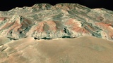
A 3D terrain model of the Grand Canyon, Northern Arizona. The map showcases prominent features of the canyon, including plataue, stream segments, and geological strata. The Grand Canyon encompasses 278 miles (447 km) of the Colorado River and adjacent uplands.
Geo-spatial mapping by ArtIsInFormation www.ArtIsInFormation.com