
描述
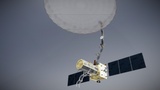
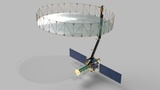
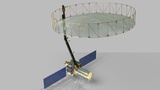
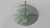
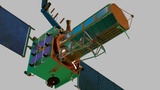
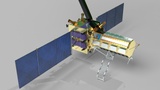
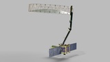
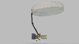
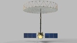
NISAR is a cutting-edge Earth observation satellite jointly developed by NASA (United States) and ISRO (India). It is designed to provide high-resolution, all-weather, day-and-night imaging of Earth’s surface using advanced Synthetic Aperture Radar (SAR) technology operating in both L-band and S-band frequencies.
Primary Objectives:
Monitor changes in Earth’s land and ice surfaces, including tectonic plate movement, landslides, and glacier dynamics.
Study ecosystem changes, agricultural patterns, and natural resources.
Track natural disasters like earthquakes, volcanic eruptions, and tsunamis to improve disaster response.
Contribute to climate change research by analyzing biomass, soil moisture, and carbon cycle dynamics.
Key Features:
Dual-frequency SAR (L-band by NASA, S-band by ISRO).
High-resolution radar imaging capability through clouds and darkness.
Large deployable radar antenna (~12 meters in diameter).
747 km sun-synchronous orbit with a 12-day repeat cycle for global coverage.
Launch:
Planned launch: 2024 (aboard GSLV Mk II from India).
Significance:
NISAR is one of the most advanced Earth science missions, aimed at improving our understanding of Earth’s dynamic systems, enhancing resource management, and supporting disaster mitigation globally.