Descripción
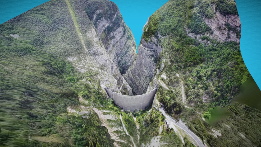
The Vajont Dam or Vaiont Dam is a disused hydro-electric dam in northern Italy. It is one of the tallest dams in the world, with a height of 262 m (860 ft).[5][6] It is in the valley of the Vajont (river) under Monte Toc, in the municipality of Erto e Casso, 100 km (62 mi) north of Venice.
The dam was conceived in the 1920s and eventually built between 1957 and 1960 by Società Adriatica di Elettricità, at the time the electricity supply and distribution monopoly in northeastern Italy. The engineer was Carlo Semenza (1893–1961).
On 9 October 1963, during initial filling of the lake, a landslide caused a megatsunami in which 50,000,000 m3 (1.8×10⁹ cu ft) of water overtopped the dam in a wave of 250 m (820 ft), bringing massive flooding and destruction to the Piave Valley below, destroying several villages and towns, causing an estimated 1,900 to 2,500 deaths.[1] The dam itself remained almost intact and two-thirds of the water was retained behind it.
This event occurred after ENEL and the Italian government concealed reports and dismissed evidence that Monte Toc, on the southern side of the lake, was geologically unstable. They had disregarded numerous warnings, danger signals, and negative appraisals.
ConstructionThe dam was built by Società Adriatica di Elettricità (SADE), the electricity supply and distribution monopoly in northeastern Italy. The owner, Giuseppe Volpi di Misurata, had been Mussolini's minister of finance for several years. The "tallest dam in the world", across the Vajont Gorge, was conceived in the 1920s to harness the Piave, Mae, and Boite Rivers, to meet the growing demand for power generation and industrialization. The project was not authorized until 15 October 1943, after the confusion following Mussolini's fall during World War II was resolved.[7]
The dam wall had a volume of 360,000 m3 (13×106 cu ft) and held up to 168.7×10⁶ m3 (5.96×10⁹ cu ft) of water. The dam and basin were intended to be at the centre of a complex water-management system in which water would have been channeled from nearby valleys and artificial basins at higher levels. Tens of kilometres of concrete pipes and pipe bridges across valleys were planned.[citation needed]
In the 1950s, SADE's monopoly was confirmed by post-fascist governments, and it bought the land despite opposition from the communities of Erto and Casso in the valley, which was overcome by government and police support.[citation needed] SADE stated that the geology of the gorge had been studied, including analysis of previous landslides, and that the mountain was held to be sufficiently stable.[citation needed]
Construction work on the dam started in 1957. By 1959, shifts and fractures in the ground were noticed while building a new road on the side of Monte Toc. This led to further studies in which three experts separately told SADE that the entire side of Monte Toc was unstable and was likely to collapse into the basin if the filling were completed, due to the raised water level increasing the instability.
Early signs of disasterOn 22 March 1959, during construction of the Vajont Dam, a landslide at the nearby Pontesei Dam created a 20-metre-high (66 ft) wave that killed one person.[9] Throughout the summer of 1960, minor landslides and earth movements were noticed. Instead of heeding these warning signs, the Italian government chose to sue the handful of journalists reporting the problems for "undermining the social order".[citation needed][10][11]
On 4 November 1960, with the water level in the reservoir at about 190 m (620 ft) of the planned 262 m (860 ft), a landslide of about 800,000 m3 (30×106 cu ft) collapsed into the lake. SADE stopped the filling, lowered the water level by about 50 m (160 ft), and started to build an artificial gallery in the basin in front of Monte Toc to keep the basin usable even if additional landslides (which were expected) divided it into two parts.[12]
In October 1961, after the completion of the gallery, SADE resumed filling the reservoir under controlled monitoring. In April and May 1962, with the basin water level at 215 m (705 ft), the people of Erto and Casso reported five "grade five" Mercalli intensity scale earthquakes. SADE downplayed the importance of these quakes, and was then authorized to fill the reservoir to the maximum level.
In July 1962, SADE's own engineers reported the results of model-based experiments on the effects of further landslides from Monte Toc into the lake. The tests indicated that a wave generated by a landslide could overtop the crest of the dam if the water level was 20 m (66 ft) or less from the dam crest. SADE therefore decided that a reduced level 25 m (82 ft) below the crest would prevent any displacement wave from over-topping the dam.
In March 1963, the dam was transferred to the newly constituted government service for electricity, ENEL. During the following summer, with the reservoir almost completely filled, landslips, shakes, and movements of the ground were repeatedly reported by the alarmed population. On 15 September 1963, the entire side of the mountain slid by 22 cm (8.7 in). On 26 September 1963, ENEL decided to slowly empty the basin to 240 m (790 ft). By early October 1963, the collapse of the mountain's south side looked unavoidable; in one day, it moved almost 1 m (3 ft).